Category Archives: HI 9808

HI 9808: Multimedia Exhibit Design

It’s easy to see why virtual exhibits appeal to museums and other institutions. Virtual exhibits allow institutions to make their collections available to anyone with internet access, while not subjecting artifacts to the rigors of travel and display. However, as with physical exhibits, not all virtual exhibits are created equal. You can’t just slap together a photo gallery and expect the page views to come rolling in. Virtual exhibits require planning and deliberation if they are going to engage visitors.

With that in mind let’s assess Manifold Greatness: The Creation and Afterlife of the King James Bible, produced by the Folger Shakespeare Library (Washington D.C.), the Bodleian Library, University of Oxford, with assistance from the Harry Ransom Center at the University of Texas at Austin. The virtual exhibit is really just one part of a multi-platform Manifold Greatness project, which also included a travelling exhibition and a book.

The core of the virtual exhibit is dived into three section: Before the King James Bible, Making the Book, and Later Influences. The content of these sections offer impressive depth and breadth of information. The Before section does an excellent job providing context for the creation of the KJB; it explains early bibles editions, English royal lineage, and 16th century religious tension. This is all explained through various media, including text, video, interactive timelines, and scans historical documents, paintings, and engravings. The virtual collection of primary sources is quite impressive, particularly the scans of early modern bibles which allow the viewer to see the craftsmanship that went into producing each copy.

The history of the King James Bible may not seem like a particularly kid-friendly topic, and the creators of the virtual exhibit could have easily kept their focus on older audiences, but instead they created a truly engaging portal for younger audiences to learn about the KJB. The Kids section, as with the whole exhibit, seeks to answer the questions: Where did it the KJB come from? How was it made? and why is it still important today? To answer these questions the Kids section uses pictures, video, short text explanations. There are also How-To videos showing visitors how to make ink, a ruff collar, a quarto (short book), and a quill pen. This is a great way to introduce new concepts and engage tactile learners. All of the online activities are thoughtful and connect to the core questions. I liked the Printer for a Day activity which allows users to typeset a line of text and “print” it with a 17th century printing press.

Manifold Greatness is a terrific virtual exhibit that explains the creation and lasting influence of the King James Bible. The site takes advantage of the web platform by presenting information using a variety of media, including video and dynamic timelines. The exhibit is thorough without being overwhelming, and the site design is clean and uncluttered. Manifold Greatness sets a high standard for virtual exhibits.


HI 9808: Rome wasn’t rebuilt in a day

In recent classes we have been learning about tools and techniques for digital mapping and 3D visualization. I love maps and, y’know… being able to see in 3D, so I can really sink my teeth into this topic.  One example we looked at was Rome Reborn. If you haven’t seen Rome Reborn before, do yourself a favour and check it out. Using archaeological data and written records the folks at the Virtual World Heritage Laboratory (VWHL) of the University of Virginia have been able to reconstruct many well known buildings in ancient Rome. Where there are limits to the available data the researchers took some artistic liberties to fill in the gaps. The finished product looks a bit like “The Sims: Ancient Rome. Now with 30% more orgies!”

This is quite an impressive project. We can really see how ancient Rome was laid out and how buildings and neighborhoods related to each other.  We have seen this sort of digital visualization applied in Hollywood films, but not so much to archaeological or historical projects. This has really got my gears going. Think about the possibilities of combining the 3D visualization of Rome Reborn with the qualitative and quantitative analysis of a specific neighborhood, as seen in Putting Harlem on the MapTime and resources permitting I would like to create a snapshot of Toronto in the 19th using city directories, fire insurance maps, and historic photographs and paintings.

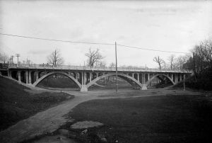
For the time being I have to be content with creating a visualization of one historic structure in Toronto. For our Digital Landscaping assignment I am examining a bridge that is no longer a bridge. Built in 1914 to replace an earlier structure, the Crawford Street bridge allowed pedestrian and vehicular traffic to cross the Garrison Creek ravine. The creek itself had been buried in a brick sewer in the 1880s because it was a noxious source of raw sewage. In the 1960s, the ravine was used as a dumping ground for earth excavated during construction of the Bloor-Danforth Subway. The ravine was filled in, right up to the level of the road surface. Adding insult to injuring from which were removed the balustrades and lamp posts.

Crawford Street Bridge, West Side, November 16, 1915. City of Toronto Archives, Fonds 1231, Item 1615

Crawford Street Bridge, West Side, November 16, 1915. City of Toronto Archives, Fonds 1231, Item 1615

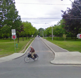
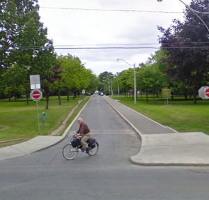
Crawford St as it appears today.

Crawford St as it appears today.


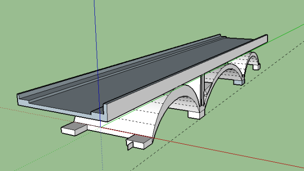
I find the story of the Crawford Street Bridge to be fascinating because it brings together so many facets of urban life, including pollution, mass transit and other infrastructure, human settlement patterns, and community activism. To digitally excavate the Crawford Street Bridge I am attempting to reconstruct it using SketchUp.

Work in progress.

SkecthUp in progress. Not to be confused with Ketchup.

Considering this is my first real experience with SketchUp I’m pretty pleased with the results so far. I look forward to practicing my skills with SketchUp. Got your own digital mapping or 3D visualization projects? Let me know I’d love to see other examples.


History Beneath Our Feet (HI 9808: Digital Landscaping — Proposal)

The Crawford Street Bridge

Crawford St is a one-way street in Toronto that runs north through Trinity Bellwoods Park to Dundas St. On the surface there is nothing particularly noteworthy about this stretch of concrete and asphalt. What few people realize is that a few feet under the paved road surface is the structure of a bridge built 100 years ago.

crawford2

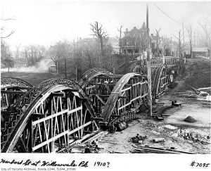
Crawford Street Bridge under construction 1914 -1915 City of Toronto Archives, fonds 1244, f1244_it7095 (handwritten caption is incorrect)

The buried bridge was the second known structure built to allow Crawford St to span the Garrison Creek ravine. The creek itself had been systematically buried in a brick sewer beginning in the 1880s because its proximity to urban development had effectively turned the creek into a polluted open sewer.

In the 1960s the deep ravine around the bridge was used a dumping ground for debris

Crawford Street Bridge, West Side, November 16, 1915. City of Toronto Archives, Fonds 1231, Item 1615

from construction of the Bloor-Danforth subway. The debris filled the ravine up to street level, completely encasing the structure of the bridge. The balustrades and lamp post were removed, leaving not outward sign of what had stood there before.

This project will graphically excavate the buried bridge and bring it into the light of day. It will be presented in the form of a slideshow with text, photographs. and maps.

Crawford St as it appears today.

Crawford St as it appears today.


Why?

By studying the construction and burial of the Crawford Street Bridge we begin to understand Toronto’s physical geography, how it has changed over time, and how the geography has shaped human settlement. The history of this unassuming stretch of road is the entry point to discussions about infrastructure (sewers, bridges, roads, transit), recreation, pollution, and a dozen other subjects of urban living.


Methodology

This project will use text, photographs, and maps to show how the physical geography of Trintiy Bellwoods Park has changed since the founding of York (Toronto) in 1793, with a particular focus on the construction and burial of the Crawford Street Bridge in the 20th century. I will use a variety of text and graphic sources, including, but not limited to, the following:

Archival Photographs — As a building project of the City of Toronto Works Department, the construction of the Crawford St. Bridge and subsequent repairs were well documented. The photographs are held by the City of Toronto archives, and many are available through the online database.
Newspaper accounts — Primarily the Toronto Star and Globe and Mail

Books and articles — The Crawford Street Bridge and its subsequent interment have been written about in a variety blogs (Torontoist, Spacing, Blog TO, and others)

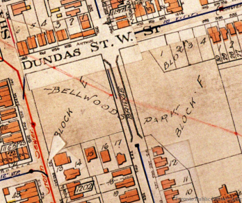
Goad's Fire Insurance Map, 1924

Goad’s Fire Insurance Map, 1924

Fire insurance and other historic maps — Historic maps show us how the the Garrison Creek and its ravine were a physical barrier to the westward expansion of the city and how the various bridges including the one on Crawford St connected the city.